Place · Travel
Praigoli, Sumba: the hill village above the Wanokaka Pasola
A sprawling Marapu village in the hills of Wanokaka, with a stone tomb close to 200 years old and views down to the Pasola field and the sea.
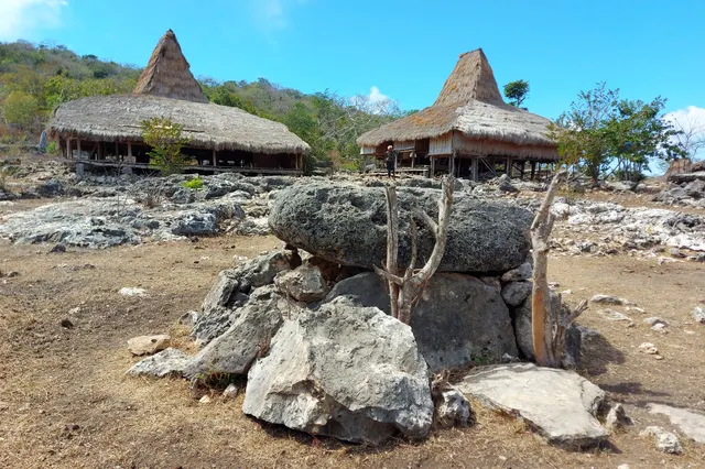
Kampung Praigoli is a traditional village in the hills of Wanokaka, West Sumba, the nearest traditional village to the Wanokaka Pasola field. Lonely Planet describes it as deeply traditional and best known for Watu Kajiwa, a tomb nearly 200 years old. You can walk up from the Pasola field; there is no ticket, so sign the guest book and leave a donation, and ask before taking photos.
- Where
- Hills of Wanokaka district, West Sumba, above the Pasola field
- From the nearest airport
- Tambolaka (TMC): roughly 1.5-2 hours by car, then a walk uphill
- Best time
- Early morning; dry season (roughly May-September)
- Entry
- No ticket; guest book and donation
- Good for
- A deeply traditional Marapu village, old stone tombs, valley views
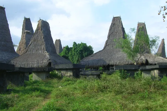
The path leaves the Pasola field and climbs between gardens and scattered houses. Halfway up you turn and the whole valley is laid out behind you: rice terraces stepping down to the river, the flat field where horsemen meet each March, a glint of sea beyond. At the top the village opens around its stones: high-peaked roofs, old graves under the trees, women weaving on a veranda, a pig asleep in the shade.
Praigoli is one of the most traditional villages of Wanokaka. It asks for time and respect, and rewards both.
What it is and why go
Praigoli (Kampung Praigoli) is a Marapu village in the hills above the south-west coast of Sumba, in Wanokaka district, West Sumba. Lonely Planet calls it "deeply traditional" and "sprawling", and says it is best known for Watu Kajiwa, a stone tomb nearly 200 years old. The Spice Route End travel blog describes it as the closest traditional village to Wanokaka, on a hill reached on foot from the Pasola field, passing settlements such as Wenenangu, and notes its famous carved stone.
Sumba this week, every Sunday
The week's news, one place worth the trip and practical travel notes. Free, and you get our 7-day Sumba guide (PDF) on signing up.
One email a week. No spam. Unsubscribe in one click. Sumba this weekWanokaka is one of the four Pasola areas of Sumba, and villages like Praigoli are tied to the ritual calendar that decides it. Visiting outside the Pasola season gives you a quieter, more personal glimpse of village life. Read Marapu, ikat and traditional villages first.
How to get there
- From Waikabubak: drive south towards Wanokaka to the Pasola field area (Sumba Information gives about 16 km), roughly 30-40 minutes, then walk uphill to the village.
- From Tambolaka (TMC): roughly 1.5-2 hours by car via Waikabubak.
- On foot: the walk from the Pasola field climbs through hamlets; ask locals for the way, or better, go with a guide from the area. Wear proper shoes.
We could not verify exact coordinates for the village itself; the map point on this page marks the Wanokaka Pasola field, the usual starting point for the walk.
When to go and best time of day
Early morning is best: cooler for the climb, soft light over the valley, and people at home before they leave for the fields. The dry season, roughly May to September, keeps paths firm. Around the Pasola (usually March in Wanokaka) the area is busy and ritual activity may limit visits; ask before going up.
Tips and etiquette
- Donation: there is no ticket. Sign the guest book and leave a donation; around IDR 10,000-40,000 per person is a common range in Sumbanese villages (2025-2026).
- Permission first: greet the first adults you meet and ask whether you may enter and take photos. Some houses, graves and objects are sacred; do not touch them.
- Dress modestly: shoulders and knees covered. A small gift of betel nut is appreciated.
- Buying ikat: if weavers offer cloth, ask how it was dyed and made, and pay fairly. See Sumba ikat: where to buy.
- Bring: water, a hat and cash in small notes.
Plan your visit
Plan a morning in Wanokaka: Praigoli on foot early, back down to the Pasola field, then Wanokaka beach before the midday heat, and Lapopu waterfall in the afternoon. From there, return to Waikabubak or continue west along the coast towards Lamboya and Marosi. With a full day, ask your guide about continuing to Waeiwuang, about 5 km beyond Praigoli. In the weeks before the Pasola, rituals take place in the villages; seeing the preparations can be extraordinary, but go only where you are clearly invited.
Nearby
- Wanokaka beach, below the village on the coast.
- Waeiwuang (Waiwuang), a traditional village about 5 km further on, which Lonely Planet says overlooks rice fields, the river and the sea and has a stone tomb with a 2.5 m carved finial.
- Lapopu waterfall, inland to the east.
- Waikabubak, with Tarung and Praijing.
Frequently asked questions
What is Watu Kajiwa?
A stone tomb in Praigoli that Lonely Planet describes as nearly 200 years old, the village's best-known monument.
How do you get to Praigoli?
Drive south from Waikabubak to the Wanokaka Pasola field, then walk uphill through the hamlets. A local guide makes it easier.
Can tourists visit Praigoli during the Pasola?
The area is crowded and ritually busy around the Pasola, usually in March. Ask locals or your guide whether visits are welcome at that time.
Places in this guide
- Wanokaka Pasola field (start of the walk to Praigoli; village coordinates not verified) · Wanokaka, West Sumba · Open in maps
Distances by road
Praigoli is in Wanokaka, West Sumba, on the island of Sumba, Indonesia: 56 km by road from Tambolaka Airport (TMC) (about 1 h 20 min to 1 h 40 min) and 146 km from Waingapu Airport (WGP) (about 3 h 30 min to 4 h 15 min).
- Regency
- West Sumba (Sumba Barat)
- From Tambolaka Airport (TMC)
- 56 km by road, about 1 h 20 min to 1 h 40 min driving
- From Waingapu Airport (WGP)
- 146 km by road, about 3 h 30 min to 4 h 15 min driving
- Nearest town
- Waikabubak: 16.3 km by road, about 25 min to 30 min
- Coordinates
- -9.7208, 119.4526 · Open in Google Maps ·
- Sunrise and sunset
- Sunrise from 05:30 (November) to 06:20 (July); sunset from 17:48 (May) to 18:30 (January), local time (WITA). Calculated for these coordinates on the 15th of each month.
Combine it in one day. The closest places by road from here, with the driving time between them:
- Wanokaka Beach3.1 km · under 10 min
- Praijing village12.7 km · 20 min
- Waikabubak15.2 km · 20 min to 25 min
Road distances were calculated on 18 November 2026 with the OSRM routing engine on OpenStreetMap roads. Driving times are our estimate at an average of 34 to 42 km/h without long stops, the pace at which the 170 km between Tambolaka and Waingapu take 4 to 5 hours. All distances between towns and places →
Nearby places
- Wanokaka Beach3 km straight-line
- Lapopu waterfall6 km straight-line
- Matayangu waterfall8 km straight-line
- Praijing village9 km straight-line
Straight-line distances between map points; roads are longer. Getting around Sumba: car with driver, scooter, buses and real driving times
- Kampung Praigoli, Lonely Planet, accessed Nov 2026
- Sumba: Wanokaka and Lemboya, The Spice Route End (travel blog), 2017
- The Southwest of Sumba, Sumba Information, accessed Nov 2026
- Traditional villages in Sumba: which ones to visit and what to expect, Backindo, accessed Nov 2026
- Lapangan atraksi pasola Wanukaka, OpenStreetMap / Nominatim (coordinates)
Spotted an error? Write to info@ecobeachcity.com.
Sumba this week, every Sunday
The week's news, one place worth the trip and practical travel notes. Free, and you get our 7-day Sumba guide (PDF) on signing up.
One email a week. No spam. Unsubscribe in one click. Sumba this week