Travel
Sumba itinerary: 5, 7 and 10 days from west to east
Fly into Tambolaka, cross the island through villages, waterfalls and savanna, and fly out of Waingapu without wasting a single day backtracking.
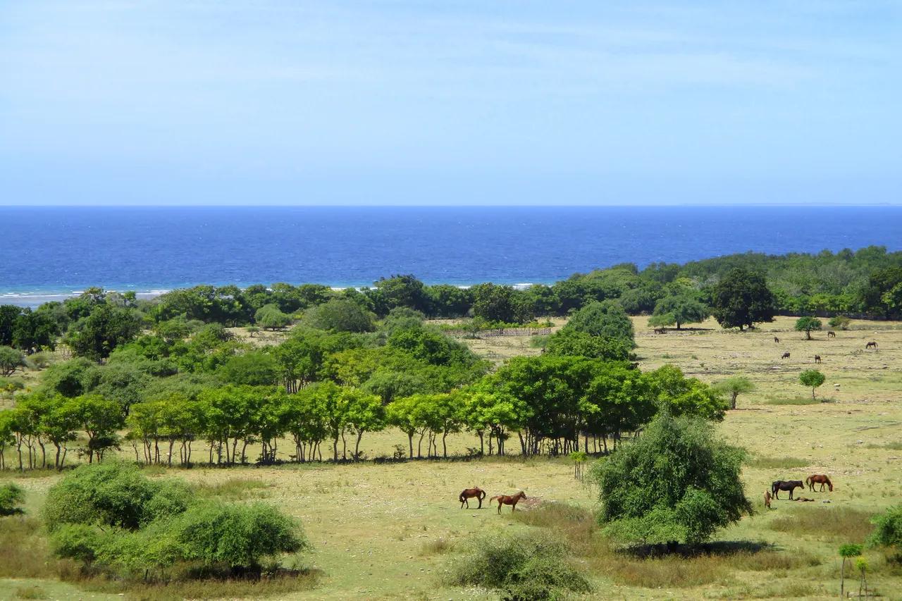
The most efficient way to see Sumba is one-way: fly into Tambolaka in the west and out of Waingapu in the east, which saves a drive of roughly 170 km. Five days covers the highlights at a fast pace, seven days is the sweet spot for most travellers, and ten days lets you add the south coast, a jungle waterfall trek and the quiet far east.
- Best route
- Fly into Tambolaka (TMC), out of Waingapu (WGP), or the reverse
- Ideal length
- 7 days; 5 at a fast pace, 10 to include the south coast
- Longest drive
- Waikabubak to Waingapu, about 130 km, 3.5-4.5 h
- Getting around
- Car with local driver, around USD 75 a day (2026)
- Village visits
- Ask permission, sign the book, contribution around USD 2-5
- Best season to drive
- Dry season, roughly May-October
The plane drops low over a coastline of white coral and dark green scrub, and then you are on the ground at Tambolaka, where the air smells of dry grass and woodsmoke. On the road out of town, children wave from the back of pickups, a man rides a small horse bareback along the verge, and the tall thatched roofs of a village rise above the cashew trees like the masts of ships. Sumba does not reveal itself in a day. It is roughly twice the size of Bali, with far fewer people and far fewer roads, and the best of it is spread from one end of the island to the other.
That is why the shape of your trip matters more than the length. The short answer: fly into Tambolaka (TMC) and out of Waingapu (WGP), or the other way round, and travel across the island once. You see the coral lagoons and Marapu villages of the west, the waterfalls of the centre and the golden savanna of the east, and you never drive the same road twice.
Before you plan: distances, roads and flights
Sumba is about 200 km long. On a map the distances look small, but roads are narrow, winding and sometimes broken, and you will stop often. A useful rule is to plan on 30-40 km per hour of driving once you leave the main trans-Sumba road. These are the key legs, with road distances measured on OpenStreetMap routing and realistic times based on local tour programmes:
Low Tide, every Sunday
One short letter a week about living well, from an island with more horses than traffic lights. Free.
We only use your email to send the letter. Unsubscribe in one click.| Leg | Distance | Realistic driving time |
|---|---|---|
| Tambolaka airport to Weekuri Lagoon | about 40 km | 1-1.5 h |
| Weekuri to Ratenggaro (Kodi) | about 23 km | 45 min-1 h |
| Tambolaka to Waikabubak | about 42 km | about 1 h |
| Ratenggaro to Waikabubak | about 80 km | 2-2.5 h |
| Waikabubak to Lapopu waterfall | about 16 km | 45 min |
| Waikabubak to Wairinding hill | about 107 km | 2.5-3.5 h |
| Waikabubak to Waingapu | about 130 km | 3.5-4.5 h (a public bus takes about 4.5 h) |
| Waingapu to Wairinding | about 25 km | 45-60 min |
| Waingapu to Tanggedu waterfall | about 46 km | about 2 h, plus a walk |
| Waingapu to Walakiri beach | about 22 km | 30-40 min |
| Waingapu to Tarimbang | about 85 km | 3 h or more |
Flights decide the shape of everything else. Wings Air flies Bali to Tambolaka several times a day (about 1 h 30), and since 15 July 2026 TransNusa flies Bali to Waingapu non-stop four times a week (Tuesday, Wednesday, Friday and Saturday). Check which days your flight out of Waingapu runs before you fix the itinerary, and keep a buffer: schedules change and flights are sometimes rescheduled. Our guide on how to get to Sumba from Bali has the details.
The easiest way to travel is a car with a local driver, who also knows which villages welcome visitors that day and can introduce you. Lonely Planet (2026) quotes around USD 75 a day with driver, roughly IDR 1.2 million (about EUR 70), and prices vary with the season and the car. See getting around Sumba and Sumba travel costs.
5 days: the fast crossing
Five days is enough to see the essentials if you accept one long driving day. It works best in the dry season, when roads are easier.
Day 1: Tambolaka, Weekuri Lagoon and Mandorak
Land at Tambolaka and drive about an hour west to Weekuri Lagoon, a saltwater lagoon of startling clarity fed by the sea through the rocks. Swim, but wear sandals: the coral is sharp. A few minutes away, Mandorak beach sits in a notch between two cliffs; in June and July the sun sets right between them. Sleep in the Tambolaka area or the north-west coast.
Day 2: Kodi villages and the drive to Waikabubak
Morning in the Kodi area. Ratenggaro is famous for its towering peaked roofs and stone tombs on a headland above the sea, with Pero beach and its fishing village close by. Take your time: these are homes, not open-air museums. In the afternoon drive about 2-2.5 hours east to Waikabubak, the small capital of West Sumba, and walk up at sunset to Kampung Tarung, a traditional hilltop village in the middle of town.
Day 3: Praijing, Lapopu and the long road east
Start early at Praijing, a village of thatched houses stepped across a hill a short drive from Waikabubak. Then head to Lapopu waterfall, about 90 m tall and falling in tiers, a 5-minute walk from the car park. After lunch, the big drive: roughly 4-5 hours with stops to Waingapu. Time it so you reach Wairinding hill, about 25 km before Waingapu, for sunset over the rolling savanna. A provincial tourism programme describes this crossing as "a journey of about 5 hours".
Day 4: The north-east savanna
Drive about 2 hours north-west from Waingapu to Tanggedu waterfall, often called the Grand Canyon of Sumba, where water has carved pools into the rock. The last stretch, nearly 3 km, is on foot or by ojek (motorbike taxi). On the way back, stop at Puru Kambera, where wild horses graze savanna that runs down to a long empty beach.
Day 5: Waingapu and departure
Visit the royal village of Prailiu on the edge of Waingapu, known for its ikat weavers (see where to buy ikat in Sumba), then climb Bukit Persaudaraan, a hill next to the airport with wide views, before your flight.
7 days: the classic west-to-east trip
Seven days is the length most guides and tour programmes recommend. It removes the long driving day and adds the south coast of the west and the far east.
- Day 1: Arrive Tambolaka. Afternoon at Weekuri Lagoon, sunset at Mandorak.
- Day 2: Kodi: Ratenggaro, Pero, and the coastal road. If you are here in February, ask your driver about the Pasola. Night in Tambolaka or Kodi.
- Day 3: Drive to Waikabubak (about 1 hour from Tambolaka). Kampung Tarung in the morning, then the Wanokaka valley south of town (about 20 km), with rice fields, villages and a wide beach, or Marosi beach on the Lamboya coast (about 30 km). Night in Waikabubak.
- Day 4: Praijing early, Lapopu waterfall, then east through Central Sumba, with a stop at Waibakul or the traditional village of Pasunga, known for its large stone tomb. Sunset at Wairinding. Night in Waingapu.
- Day 5: Tanggedu waterfall and Puru Kambera.
- Day 6: The south-east: the villages of Praiyawang (Rindi) and the Rende area, about 70 km and 2 hours from Waingapu, known for great stone tombs and ikat. Return along the coast for sunset at Walakiri, where small mangroves stand on the sand like dancers. Check the tide: at high tide they are under water.
- Day 7: Prailiu and Bukit Persaudaraan, then fly out of Waingapu.
10 days: slow Sumba
With ten days you can stop rushing, stay two nights in each base and reach places most visitors never see.
- Days 1-2: North-west and Kodi at an easy pace: Weekuri, Mandorak, Ratenggaro, Pero, and the quieter coast around Bondo Kodi.
- Day 3: Waikabubak, Kampung Tarung, an afternoon in Wanokaka.
- Day 4: Lapopu, then the trek to Matayangu, a waterfall in Manupeu Tanah Daru National Park. Lonely Planet describes it as about a 90-minute hike from the same parking area as Lapopu; trails are steep and slippery, so go with a local guide.
- Day 5: Lamboya and the south-west coast (Marosi), or a rest day. Night in Waikabubak.
- Day 6: Praijing, Pasunga and Waibakul, a slow crossing through Central Sumba to Wairinding for sunset.
- Day 7: Tanggedu and Puru Kambera.
- Days 8-9: South coast: Tarimbang, a wide bay on the south coast of East Sumba, reached by a winding road over the hills (allow at least 3 hours from Waingapu). Stay a night, swim when the sea is calm, and watch the surf. On the way, you can glimpse the forested hills of Laiwangi Wanggameti National Park, home of the highest ground on the island.
- Day 10: Back to Waingapu, Walakiri at sunset if your flight is the next morning, or Prailiu before an afternoon flight.
Surfers can swap the south-coast days for a longer stay on the west coast. See our guide to surfing in Sumba.
Visiting villages with respect
Many Sumbanese still follow Marapu, the ancestral religion, and the villages you visit are living homes where ceremonies, burials and daily life go on. Ask before you photograph people or enter a house, sign the guest book, and leave a small contribution: Lonely Planet (2026) puts typical village fees at around USD 2-5 per person, paid to the village head or through your guide. Dress modestly, never sit or stand on the stone tombs, and do not touch ritual objects. Our guide to Marapu, ikat and traditional villages explains more.
Beaches and viewpoints often have an informal fee collected by local caretakers. At Wairinding it has been around IDR 10,000 per person, and at Tanggedu around IDR 5,000, with about IDR 50,000 for a return ojek ride from the village (2024 figures, they change). Carry small notes: ATMs are mostly in Waingapu, Waikabubak and Tambolaka.
Practical tips for any length
- Go east to west or west to east? Either works. Starting in the west puts the softer days (lagoons, beaches) first and the savanna sunsets at the end.
- Season changes the route. In the rainy season, roughly December to March, some tracks to waterfalls and the south coast become muddy or impassable and waterfalls run brown. Read our month-by-month guide.
- Start early. Light is softer, it is cooler, and you will arrive before the midday heat.
- Download offline maps. Mobile signal drops in the hills.
- Bring: cash in small notes, reef shoes or sandals, sunscreen, a hat, insect repellent and a sarong for village visits. Read our safety and health guide.
- Eat local. Simple warungs in every town serve fish, rice and vegetables; see Sumbanese food.
- Where to sleep. Bases that work: Tambolaka or the north-west coast, Waikabubak, and Waingapu. See where to stay in Sumba.
Whatever length you choose, leave space for the unplanned: a horse race on a village field, an invitation to chew betel nut, a funeral you are asked to watch from a distance. In Sumba those moments are often the trip.
Frequently asked questions
How many days do you need in Sumba?
Seven days is ideal for a west-to-east crossing. Five days works at a fast pace with one long driving day; three or four days is enough for only one end of the island.
Should I fly into Tambolaka or Waingapu?
Fly into one and out of the other. Tambolaka has several daily flights from Bali; Waingapu has a direct TransNusa flight from Bali four times a week (Tue, Wed, Fri, Sat) since July 2026.
How long is the drive from Tambolaka to Waingapu?
About 170 km. Without stops it takes roughly 4-5 hours; with sightseeing on the way, plan a full day.
Can I see Sumba without a driver?
Yes, by renting a motorbike or car, but roads are winding and signage is poor. A local driver is easier and helps with village introductions.
Is it worth going to East Sumba?
Yes. The savanna hills of Wairinding and Puru Kambera, Tanggedu waterfall and the stone tombs of Praiyawang are very different from the west.
Can I do Sumba in the rainy season?
Yes, but expect muddy tracks, brown waterfalls and slower driving, roughly December to March. Keep the itinerary flexible.
Places in this guide
- Tambolaka Airport (Lede Kalumbang) · Southwest Sumba · Open in maps
- Tambolaka · Southwest Sumba · Open in maps
- Weekuri Lagoon · Southwest Sumba · Open in maps
- Ratenggaro village · Southwest Sumba · Open in maps
- Pero beach · Southwest Sumba · Open in maps
- Bondo Kodi · Southwest Sumba · Open in maps
- Waikabubak · West Sumba · Open in maps
- Kampung Tarung · West Sumba · Open in maps
- Wanokaka beach · West Sumba · Open in maps
- Marosi beach · West Sumba · Open in maps
- Lapopu waterfall · West/Central Sumba · Open in maps
- Matayangu waterfall · Central Sumba · Open in maps
- Manupeu Tanah Daru National Park · Central Sumba · Open in maps
- Pasunga village · Central Sumba · Open in maps
- Waibakul · Central Sumba · Open in maps
- Wairinding hill · East Sumba · Open in maps
- Puru Kambera beach · East Sumba · Open in maps
- Puru Kambera savanna · East Sumba · Open in maps
- Waingapu · East Sumba · Open in maps
- Prailiu royal village · East Sumba · Open in maps
- Bukit Persaudaraan · East Sumba · Open in maps
- Waingapu Airport (Umbu Mehang Kunda) · East Sumba · Open in maps
- Walakiri beach · East Sumba · Open in maps
- Praiyawang (Rindi) · East Sumba · Open in maps
- Tarimbang · East Sumba · Open in maps
- Laiwangi Wanggameti National Park · East Sumba · Open in maps
- A guide to Sumba, Indonesia, Lonely Planet (Charukesi Ramadurai), 10 April 2026
- Sumba Adventure 7D6N package, Dinas Pariwisata Kabupaten Sumba Barat Daya
- Sumba ultimate guide, Seek Sophie
- How to get to Waingapu (bus times), Travelfish
- Air Terjun Tanggedu, pesona alam kelas dunia di Sumba Timur, GoodNewsFromIndonesia, 7 February 2024
- Wairinding Hills, Sumba: best time and tips, Backindo
- Mata Yangu Waterfall, Travelfish
- Sumba travel 2026: east vs west route and seven essential tips, Telkomsel
Spotted an error? Write to info@ecobeachcity.com.
Low Tide, every Sunday
One short letter a week about living well, from an island with more horses than traffic lights. Free.
We only use your email to send the letter. Unsubscribe in one click.