Travel
Central Sumba (Sumba Tengah): what to know before you go
The regency most travellers drive straight through hides Sumba's greatest stone tombs, a jungle waterfall and quiet villages on the Anakalang plain. Here is why to stop.
Central Sumba (Kabupaten Sumba Tengah) is the least populous of Sumba's four regencies, about 1,790 km² with roughly 94,000 people (BPS mid-2025 estimate), governed from Waibakul on the Anakalang plain, about 20 km east of Waikabubak. It has no airport: it lies on the main road between Tambolaka (about 58 km) and Waingapu (about 107 km). Stop for the carved megalithic tombs of Anakalang, such as Pasunga and Gallubakul, and the Matayangu waterfall in Manupeu Tanah Daru National Park, but bring cash from Waikabubak or Waingapu.
- Capital
- Waibakul (Anakalang plain, about 400 m)
- Size and population
- 1,789.69 km²; 94,187 people (BPS mid-2025 estimate), the least populous regency
- Getting there
- No airport: about 58 km from Tambolaka, 20 km from Waikabubak, 107 km from Waingapu
- Highlights
- Anakalang tombs (Pasunga, Kabunduk, Gallubakul), Matayangu waterfall
- Best time
- Dry season, roughly May-September
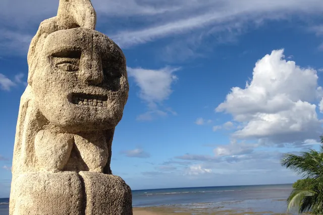
East of Waikabubak the road climbs through forest, then levels out onto a wide green plain at about 400 m. Rice fields stretch to the foot of the hills, buffaloes wallow in the ditches and, right beside the road, a massive stone slab carved with the figures of a chief and his wife stands over a grave, hands on hips, as it has since 1926. This is Anakalang, heart of Central Sumba, and most travellers see it only through a car window on the long drive across the island.
The short version: Central Sumba is small, rural and quiet, with no airport and few facilities for visitors. It rewards a half day or a full day on the way between west and east, for its megalithic tombs, a waterfall and the villages on the edges of the plain.
Central Sumba at a glance
Central Sumba Regency (Kabupaten Sumba Tengah) was created on 22 May 2007 from parts of West Sumba and East Sumba. It covers 1,789.69 km² and had an estimated 94,187 inhabitants in mid-2025, according to BPS figures published on Wikipedia, which makes it the least populous regency on the island. It has six districts and 65 villages, all classed as rural.
Low Tide, every Sunday
One short letter a week about living well, from an island with more horses than traffic lights. Free.
We only use your email to send the letter. Unsubscribe in one click.The capital, Waibakul, lies on the Anakalang plain in Katikutana district, whose administrative centre is Anakalang. It is a young administrative town of government buildings among the rice fields rather than an old trading centre. The southern districts, Katikutana and South Katikutana, include much of Manupeu Tanah Daru National Park. To the north, Mamboro and the Umbu Ratu Nggay districts reach the north coast, where Mamboro village serves as a small port.
How to get there
- From Tambolaka airport (TMC): about 58 km to Waibakul, roughly 1.5 hours by car via Waikabubak.
- From Waikabubak: about 20 km east on the main road, around 30 minutes.
- From Waingapu (WGP): about 107 km west, roughly 3 hours via Lewa; the road crosses the western part of Manupeu Tanah Daru National Park before reaching the plain.
- By bus: the Waingapu-Waikabubak buses pass through, and stop right outside Pasunga village.
For flights to the island, see how to get to Sumba from Bali.
The landscape
Central Sumba sits on the island's hilly spine, between the dry east and the green west. Coming from Lewa, the landscape grows gentler and greener, passing through mountains, river valleys and dense deciduous forest in the national park. The Anakalang plain is irrigated rice country ringed by hills, with original villages on almost every hilltop around its edges. In the south, the park descends through forest and grassland to remote bays on the Indian Ocean, such as Konda and Maloba, about 35 km from Gallubakul; parts of that coast are now private land and fenced off.
Main places to visit
The Anakalang tombs
Anakalang has some of the largest megalithic tombs on Sumba, and they are more richly carved than those elsewhere. Good starting points:
- Kampung Pasunga: right beside the main road, about 22 km east of Waikabubak, opposite the junction at Waibakul. Its best-known tomb is an upright slab carved with a chief and his wife, made in 1926; it took six months to carve, and 150 buffaloes were sacrificed for the funeral. Villagers are used to visitors.
- Kabunduk: a village about 1 km south of Pasunga, where old and new buildings mix. From here, with a local companion, you can walk up to the hilltop hamlets of Makatakeri and Lai Tarung for views over the rice plain.
- Gallubakul: further south, beside the road, the tomb of Umbu Sawola weighs about 70 tonnes, the second largest on Sumba after the 79-tonne tomb raised for Umbu Jadar in 2022.
Waterfall and forest
- Matayangu: a waterfall of roughly 75-80 m in Manupeu Tanah Daru National Park, falling into a turquoise pool. The approach is a steep, slippery descent through jungle, best with a local guide and in the dry season. It is a sacred site in Marapu belief.
- Lapopu: downstream in West Sumba and easier to reach, usually visited from Waikabubak.
Nearby in West Sumba are the villages of Tarung and Praijing at Waikabubak; to the east, the road continues across the savanna to Wairinding.
Culture: languages, villages and tombs
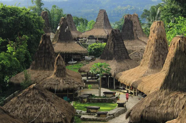
The main local languages are Anakalang on the plain and Mamboru (also written Momboru) in the north, alongside Indonesian. English is rarely spoken, so a driver or guide who knows the area makes a big difference; our Sumba phrasebook covers the basics. Many traditional houses near the main road now have corrugated metal roofs; to see thatched roofs you need to go a few kilometres off the main routes.
Central Sumba has no Pasola of its own; the nearest fields are in Wanokaka and Lamboya in West Sumba (see Pasola explained). Funerals, with the dragging of tomb stones and buffalo sacrifices, remain central to life here. Read Marapu, ikat and traditional villages before you go: sign the guest book, leave a small donation, dress modestly, ask before taking photos and never climb on or touch the tombs.
Practicalities
- Cash: do not count on ATMs in Waibakul. The most reliable machines for foreign cards (BNI and Mandiri) are in Waikabubak, Waingapu and Tambolaka, so arrive with enough small notes.
- Health: Waibakul has a small regency hospital and there are puskesmas in the districts, but for anything beyond basic care the nearest larger hospital is RSUD Waikabubak, about 20 km west. See our safety and health guide.
- Fuel: fill up in Waikabubak or Waingapu before crossing the island; stations are few in between, and fuel queues and purchase limits were reported in the west in October 2026. See getting around Sumba.
- Signal: Telkomsel works along the main road; expect no signal in the national park and the southern valleys.
- Food and beds: options in Waibakul are very limited; most travellers sleep in Waikabubak and visit as a day trip. See where to stay in Sumba.
When to go
The dry season, roughly May to September, is easiest for the side roads, the villages on the hills and the trail to Matayangu. In the rainy months, roughly December to March, the plain is at its greenest and the waterfall at its most powerful, but jungle paths become slippery and some tracks impassable. Visit villages in the morning or late afternoon, and avoid Sunday mornings, when many people are at church. For more ideas along the way, read beaches, lagoons and waterfalls.
Frequently asked questions
What is the capital of Central Sumba?
Waibakul, a young administrative town on the Anakalang plain, about 20 km east of Waikabubak.
Does Central Sumba have an airport?
No. The nearest airport is Tambolaka (TMC), about 58 km and roughly 1.5 hours away; Waingapu (WGP) is about 107 km to the east.
What is there to see in Central Sumba?
The carved megalithic tombs of Anakalang (Pasunga, Kabunduk, Gallubakul), the villages on the hills around the plain, and Matayangu waterfall in Manupeu Tanah Daru National Park.
Is there a Pasola in Central Sumba?
No. The nearest Pasola fields are in Wanokaka and Lamboya in West Sumba (February-March).
Can I stay overnight in Central Sumba?
Options are very limited, so most travellers stay in Waikabubak, about 30 minutes away, and visit Anakalang and Matayangu as a day trip.
Places in this guide
- Waibakul · Central Sumba · Open in maps
- Central Sumba Regency, Wikipedia (area, districts, BPS mid-2025 population)
- Waibakul, Wikipedia (location and road distances)
- Waibakul, Anakalang and Surroundings, Sumba Information (Matthias Jungk), accessed Nov 2026
- Kampung Pasunga, Lonely Planet, accessed Nov 2026
- Tips and Tricks (banks, phone, Sundays), Sumba Information, accessed Nov 2026
- Sumba, Wikipedia (languages, megalithic tradition)
- Waibakul, OpenStreetMap / Nominatim (coordinates)
Spotted an error? Write to info@ecobeachcity.com.
Low Tide, every Sunday
One short letter a week about living well, from an island with more horses than traffic lights. Free.
We only use your email to send the letter. Unsubscribe in one click.