Travel
Southwest Sumba (Sumba Barat Daya): what to know before you go
The airport, the lagoon, the high-roofed villages of Kodi and the February Pasola: Southwest Sumba is where most trips begin. Here is how it fits together.
Southwest Sumba (Kabupaten Sumba Barat Daya) is the most populous of Sumba's four regencies, about 1,382 km² with roughly 335,000-366,000 people depending on the BPS release, and its capital Tambolaka has the island's busiest airport (TMC), with several daily flights from Bali. It covers the Kodi region in the far west (Weekuri Lagoon, Mandorak, Ratenggaro, Wainyapu, the February and March Pasola) and the Wewewa highlands inland. Withdraw cash and fill up in Tambolaka, then allow 1-2 hours by car to the Kodi coast.
- Capital
- Tambolaka (Waitabula)
- Size and population
- 1,381.94 km²; about 335,000-366,000 people (BPS mid-2025, figures vary by release)
- Airport
- Tambolaka (TMC), several daily flights from Bali
- Highlights
- Weekuri Lagoon, Mandorak, Pero, Ratenggaro, Wainyapu, Waikelo Sawah
- Pasola
- Kodi, Kodi Bangedo and Kodi Balaghar (February and March)
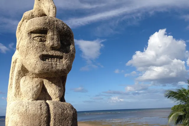
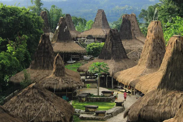
The plane comes in low over pale limestone and green fields and lands on a runway where horses graze along the fence. An hour later you are on the west coast: surf booming against a reef, the smell of salt and woodsmoke, and on a rise above the sea a village of towering thatched roofs, their peaks leaning like tall hats over a field of stone tombs. Southwest Sumba is the island's front door, and it wastes no time making an impression.
The short version: Southwest Sumba is the busiest regency for travellers, with the main airport, the most famous lagoon and beaches, and the traditional villages of Kodi. It is also the most densely populated part of the island, so expect more traffic and more people than in the east.
Southwest Sumba at a glance
Southwest Sumba Regency (Kabupaten Sumba Barat Daya) was created on 2 January 2007 from part of West Sumba. It covers 1,381.94 km² and has 11 districts and 175 villages. Population figures vary between BPS releases: the regency's mid-2025 estimate as published on Wikipedia is 366,496, while earlier BPS-based figures put it nearer 335,500. Either way it is the most populous regency on Sumba, with well over 200 people per km².
Low Tide, every Sunday
One short letter a week about living well, from an island with more horses than traffic lights. Free.
We only use your email to send the letter. Unsubscribe in one click.The regency falls into two cultural halves. The western part is Kodi, split into the districts of Kodi, Kodi Utara, Kodi Bangedo and Kodi Balaghar, with its main village at Bondo Kodi. The larger eastern part is the Wewewa (Weyewa) homeland, a green upland of farms and villages that runs towards Waikabubak.
The capital, Tambolaka, is part of the town long known as Waitabula (Weetebula). The Kota Tambolaka district had about 41,000 people in the 2025 estimate. It has the largest permanent market on Sumba, a Catholic cathedral and hospital, and the island's main western port at Waikelo, a few kilometres north.
How to get there
- By air: Tambolaka airport (TMC, also called Lede Kalumbang) is just north of town. Wings Air flies from Bali several times a day, about 1h30. See how to get to Sumba from Bali.
- By sea: the Waikelo-Sape ferry to Sumbawa reopened in May 2026.
- From Waingapu: about 170 km and 4-5 hours by car, or roughly 4-6 hours by bus or shared car via Waikabubak.
- To Kodi: shared minibuses from Tambolaka to Bondo Kodi take about an hour; most of the coast's sights need your own car and driver.
The landscape
Around Tambolaka the north-west plain is dry, with cashew plantations and grassland running down to a coast of white beaches and fishing villages. Inland, the Wewewa uplands are green all year and intensively farmed. In the far west, Kodi is a land of coral limestone, reef-fringed beaches and big Indian Ocean swell, with beaches stretching about 15 km from the island's western tip to the south-east. In early October 2026 a magnitude 6.1 earthquake struck at sea off Kodi; there was no tsunami, but some homes and churches were damaged.
Main places to visit
The Kodi coast
- Weekuri Lagoon: a turquoise saltwater lagoon fed through the coral rock, about 1.5-2 hours from Tambolaka.
- Mandorak: a tiny cove between cliffs, about a kilometre from Weekuri.
- Pero: a fishing village and sunset beach near Bondo Kodi, with surf at the right tide.
- Bawana (Mbawana): cliffs and a beach reached by a steep path; its famous rock arch collapsed in 2020.
- Watu Maladong: limestone rock islands at the mouth of the Polapare river. Look, do not swim.
Villages
- Kodi: the region known for the island's tallest house roofs.
- Ratenggaro: high-roofed houses and stone tombs by the sea, about 1-1.5 hours from Tambolaka.
- Wainyapu: across the river from Ratenggaro, with around 1,400 megalithic tombs and a March Pasola field. Much of the village burned in September 2022; visit with respect.
Around Tambolaka and Wewewa
- Waikelo Sawah: an underground river spilling out of a cave in East Wewewa, about 45 minutes from the airport.
- The Rumah Budaya Sumba, a cultural centre and collection about 2 km west of town on the Pero road, and the Lendungara plateau east of town for views over the coastal plain.
Culture: languages, Pasola and villages
Two main languages are spoken. Weyewa (Wejewa) has about 65,000 speakers in the eastern districts; Kodi, with roughly 20,000 speakers, is classed as endangered. Both are quite different from Kambera in the east. Indonesian is used with visitors; see our Sumba phrasebook.
Kodi holds the longest Pasola season on the island: two rounds of three Pasola each, in February and March, across Kodi, Kodi Bangedo and Kodi Balaghar, with Wainyapu one of the best-known fields. The dates are set each year by the Rato elders after the nyale sea worms appear and are usually confirmed in late January; check Pasola explained. Many Kodi villages follow Marapu. Read Marapu, ikat and traditional villages before going: sign the guest book, leave a donation of around IDR 20,000 or more per person (2025-2026), ask before photos, and never touch tombs or ritual objects.
Practicalities
- Cash: withdraw in Tambolaka. BNI and Mandiri ATMs are the most reliable with foreign cards; there are none on most of the Kodi coast, and the airport has no money exchange.
- Health: Tambolaka has a Catholic hospital, RS Karitas in Waitabula, and the regency hospital RSUD Reda Bolo, which was still a basic Class D hospital in 2025 with an upgrade under way. For anything serious, plan on evacuation to Bali; see our safety and health guide.
- Fuel: queues formed at several stations in Southwest Sumba in October 2026. Pertamina sent extra supplies, and the local government capped purchases of Pertalite and Pertamax at 5 litres per motorbike and 15 litres per car. Fill up in Tambolaka before heading west; see getting around Sumba.
- Signal: Telkomsel covers the towns and main roads; coverage is patchy on the Kodi coast.
- Safety: do not swim near river mouths around Waikelo, Katewel or Wainyapu (crocodiles), respect rips at the reef beaches, and plan to be back on the main road before dark; travel advisories have long urged caution after dark in remote parts of Kodi.
When to go
The dry season, roughly May to September, is best for the lagoon, the beaches and the roads to Kodi; July and August are the busiest months and rooms fill quickly. February and March are the Pasola months, wetter but unforgettable if your dates match. The rainy season, roughly December to March, brings green hills and heavier seas. For more, see beaches, lagoons and waterfalls and where to stay in Sumba.
Frequently asked questions
What is the capital of Southwest Sumba?
Tambolaka, part of the town long known as Waitabula (Weetebula). The island's busiest airport, Tambolaka (TMC), is just north of the centre.
How far is Weekuri Lagoon from Tambolaka airport?
Roughly 40-60 km depending on the route, about 1.5-2 hours by car.
Where is the Pasola in Southwest Sumba?
In the Kodi region: two rounds of three Pasola, in February and March, in Kodi, Kodi Bangedo and Kodi Balaghar (including Wainyapu). The Rato elders announce the dates, usually in late January.
Is Southwest Sumba safe for tourists?
Generally yes. Take normal precautions, avoid driving after dark in remote parts of Kodi, keep away from river mouths because of crocodiles, and respect strong currents at reef beaches.
Are there ATMs in Kodi?
Not on most of the coast. Withdraw enough cash in Tambolaka for donations, entry fees, food and fuel before you head west.
Places in this guide
- Tambolaka · Southwest Sumba · Open in maps
- Southwest Sumba Regency, Wikipedia (area, districts, BPS mid-2025 population, tourism)
- Waitabula, Tambolaka and Surroundings, Sumba Information (Matthias Jungk), accessed Nov 2026
- The Southwest of Sumba (Kodi coast, Wainyapu), Sumba Information, accessed Nov 2026
- Tips and Tricks (banks, phone), Sumba Information, accessed Nov 2026
- Kodi language, Wikipedia
- Wejewa (Weyewa) language, Omniglot, accessed Nov 2026
- Karitas Hospital, Southwest Sumba, Faculty of Medicine Universitas Indonesia
- Pertamina menyalurkan 2.500 kl BBM memperkuat pasokan di wilayah Sumba, ANTARA Kupang, 28 Oct 2026
Spotted an error? Write to info@ecobeachcity.com.
Low Tide, every Sunday
One short letter a week about living well, from an island with more horses than traffic lights. Free.
We only use your email to send the letter. Unsubscribe in one click.