Travel
Manupeu Tanah Daru National Park, Sumba: visitor guide
The last big lowland forest of western Sumba, home to the Sumba hornbill, the Sumba cockatoo and the island's most famous waterfalls.
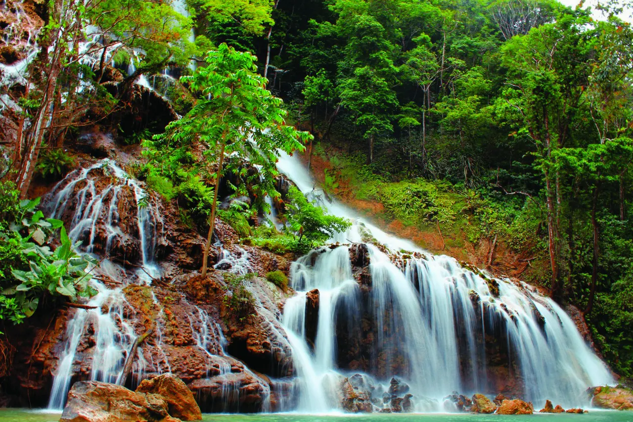
Manupeu Tanah Daru is a national park in West and Central Sumba, created in 1998 and now managed with Laiwangi Wanggameti as Matalawa National Park, the only national park on the island. It protects steep lowland forest rising to roughly 600-900 m, rare endemic birds such as the Sumba hornbill, and the Lapopu and Matayangu waterfalls. Waikabubak (about 16-25 km from the main entrances) is the base, around 1-1.5 hours from Tambolaka airport; most visitors come for the waterfalls in the dry season and for birdwatching early in the morning.
- Where
- West and Central Sumba; part of Matalawa National Park
- From the nearest airport
- Tambolaka (TMC): about 1-1.5 hours to Waikabubak, then 40 min-1.5 h to entrances
- Best time
- Dry season (about May-October) for trails; first light for birds
- Entry
- Per-site tickets; Lapopu around IDR 150,000 for foreigners in recent years
- Good for
- Waterfalls, endemic birds (Sumba hornbill, cockatoo), forest walks
Dawn on the edge of the forest south of Waikabubak. The grassland is silver with dew, the trees ahead are still dark, and the first sounds are birds: the harsh call of cockatoos, the whoosh of a hornbill's wings as it crosses a valley, a chorus of smaller voices you cannot name. Somewhere below, a river runs through limestone towards the sea. This is one of the last places where you can still see what much of Sumba looked like before the forests were cleared for grazing and fields.
What the park is and why go
Manupeu Tanah Daru National Park was established in 1998 to protect the largest remaining block of lowland forest on Sumba, on steep slopes that rise from near sea level to roughly 600-900 m. Its official size differs between sources: Wikipedia gives about 88,000 ha, while Indonesian reporting gives about 50,000 ha for Manupeu Tanah Daru and about 92,000 ha for the combined Matalawa park (Manupeu Tanah Daru plus Laiwangi Wanggameti in East Sumba). Either way, it is a large and largely roadless area across West and Central Sumba.
The park is above all a bird reserve. Sumba has several endemic species, among them the Sumba hornbill (julang sumba), the Sumba yellow-crested cockatoo, the Sumba green pigeon, the Sumba flycatcher, the Sumba cicadabird and the apricot-breasted sunbird. The hornbill and the cockatoo are the park's two priority endangered species. Matalawa has recorded more than 150 bird species, along with long-tailed macaques, Timor deer and dozens of butterfly species. For most travellers, though, the park means waterfalls: Lapopu and Matayangu.
How to get there
- From Tambolaka airport (TMC): about 42 km to Waikabubak (roughly 1 hour), then 16-25 km more to the Lapopu or Matayangu entrances (about 40 minutes to 1.5 hours).
- From Waingapu (WGP): about 130-150 km, realistically 3.5-5 hours by car via Waibakul and Waikabubak.
- Inside the park: there are few roads. Access is via the waterfall entrances, villages on the park edge, and a birdwatching area near the main road; a car with a driver who knows the area is the practical choice.
When to go and the best time of day
The dry season, roughly May to October, brings safer trails, clearer water at the waterfalls and easier driving. Some local operators recommend roughly March-June and October-December for the greenest forest and birding, and September has been highlighted for seeing hornbills. Whatever the month, go early: birds are most active from first light until about 9 am, and the forest is cooler. Afternoons in the rainy season (roughly December-March) often bring storms that make trails slippery.
Tips and etiquette
- Fees: pay at the ranger post of each site and ask for a ticket. At Lapopu foreigners have paid around IDR 150,000 per person in recent years (roughly EUR 8 or USD 9), Indonesians much less; fees change.
- Guides: hire a local or park guide for any walk beyond the waterfall paths, and a specialist guide for birding. Bring binoculars.
- Gear: shoes with grip, long trousers, insect repellent, leech socks in the wet season, at least 1.5 litres of water per person.
- Respect: many springs, caves and waterfalls are sacred Marapu sites. Ask before entering caves or photographing ritual places, keep noise down and take all rubbish out.
- Do not feed macaques or buy wild birds: the cockatoo trade is one of the reasons the species is endangered.
Nearby
- Waikabubak town, the gateway and the best base for the park.
- Tarung village and Praijing village for Marapu culture.
- Laiwangi Wanggameti National Park, the eastern half of Matalawa, in East Sumba.
Frequently asked questions
What is Matalawa National Park?
The joint name for Manupeu Tanah Daru (West and Central Sumba) and Laiwangi Wanggameti (East Sumba) national parks, managed by one office. It is the only national park on Sumba.
What birds can you see in Manupeu Tanah Daru?
Sumba endemics such as the Sumba hornbill, the Sumba yellow-crested cockatoo, the Sumba green pigeon, the Sumba flycatcher and the apricot-breasted sunbird, among more than 150 species recorded in Matalawa.
Which waterfalls are in Manupeu Tanah Daru National Park?
The best known are Lapopu, an easy walk from the road, and Matayangu, reached by a harder jungle trek. Both are south and south-east of Waikabubak.
How big is Manupeu Tanah Daru National Park?
Sources differ: about 50,000 ha according to Indonesian reporting, about 88,000 ha according to Wikipedia. The combined Matalawa park covers about 92,000 ha.
Places in this guide
- Manupeu Tanah Daru National Park · West and Central Sumba · Open in maps
- Manupeu Tanah Daru National Park, Wikipedia
- Daftar taman nasional di Bali dan Nusa Tenggara, Kompas.com, 22 May 2023
- Manupeu Tanah Daru National Park in Sumba, Authentic Indonesia
- Lapopu waterfall set to wow tourists, The Jakarta Post, 1 April 2017
- La Popu waterfall, Travelfish (Sally Arnold)
- Coordinates: Taman Nasional Manupeu Tana Daru, OpenStreetMap (relation 7230355)
Spotted an error? Write to info@ecobeachcity.com.
Low Tide, every Sunday
One short letter a week about living well, from an island with more horses than traffic lights. Free.
We only use your email to send the letter. Unsubscribe in one click.