Travel
Wairinding Hill, Sumba: when to go, how to get there, what to know
Rolling grass hills that turn from green to gold with the seasons, half an hour from Waingapu: the most famous view in East Sumba and how to see it well.
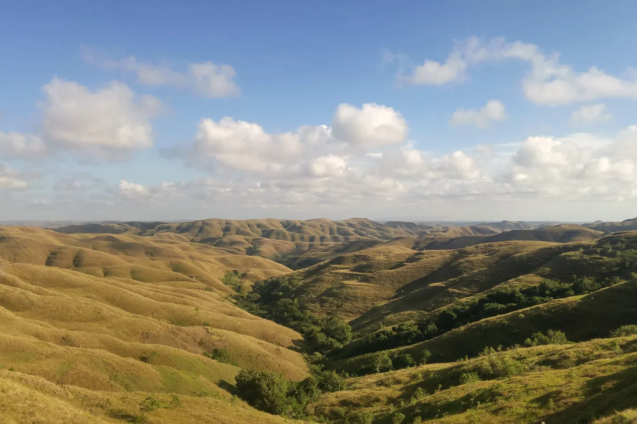
Wairinding Hill (Bukit Wairinding) is a savanna viewpoint about 20-25 km west of Waingapu on the main road to Waikabubak, roughly 30-45 minutes by car. There is no official entrance fee, though a small parking charge has been reported; go at sunrise or in the late afternoon, and in the dry season (roughly May-September) for golden hills or the rainy season for green ones.
- Where
- Main Waingapu-Waikabubak road, East Sumba, about 20-25 km west of Waingapu
- From the nearest airport
- Waingapu (WGP): about 30-45 minutes by car; Tambolaka (TMC): roughly 4 hours
- Best time
- Sunrise or late afternoon; dry season for gold, rainy season for green
- Entry
- No official fee; small parking charge sometimes collected
- Good for
- Landscape photography, sunsets, a short walk
The road climbs out of Waingapu, the houses thin out, and then the land simply opens. From the top of Wairinding the hills roll away in every direction like a rumpled blanket, folds and ridges catching the low sun, each hollow a shade darker than the last. In the dry months the grass is the colour of straw and honey; after the rains it turns a soft, almost unreal green. The wind is constant, you hear it moving through the grass, and sometimes the bells or calls of herders bringing cattle or horses down a distant slope.
Wairinding is the classic image of East Sumba, and it is easy to reach. This page explains where it is, when the light is best and how to visit without being the visitor locals remember for the wrong reasons.
What it is and why go
Bukit Wairinding is an area of grassy, rounded hills in East Sumba Regency, part of the savanna landscape that covers much of the drier eastern half of the island. Official Indonesian tourism material describes it as green in the wet season and golden-brown in the dry season, and recommends sunset. The hills appeared in the Indonesian films Pendekar Tongkat Emas (2014) and Susah Sinyal (2017), which helped make it famous with domestic travellers and wedding photographers.
Low Tide, every Sunday
One short letter a week about living well, from an island with more horses than traffic lights. Free.
We only use your email to send the letter. Unsubscribe in one click.There is no building, no trail system and nothing to "do" except walk up, sit and watch the light change. That is the point. For many travellers it is the moment they understand how different East Sumba is from the green, forested west.
How to get there
Wairinding is on the main trans-Sumba road between Waingapu and Waikabubak. Sources give the distance as just under 20 km to about 25 km from Waingapu, and the drive takes roughly 30-45 minutes. Cars and motorbikes can both get there. From the roadside parking area it is a short but rocky uphill walk, around 500 m, to the top.
- From Waingapu airport (WGP): about 30-45 minutes; an easy first or last stop on an East Sumba trip.
- From Tambolaka (TMC): Tambolaka to Waingapu is about 170 km and 4-5 hours by car, and Wairinding is on that road, so allow roughly 4 hours and stop on the way east.
There is no regular public transport to the viewpoint itself. Most visitors come with a car and driver or a rented scooter; recent guides put scooter hire from around IDR 100,000 per day and a car with driver from around IDR 500,000 per day in Waingapu (2025-2026, prices vary).
When to go and best time of day
Come at sunrise or in the last hour or two before sunset, when the side light makes the folds of the hills stand out. Midday is flat, hot and shadeless. For colour:
- Dry season (roughly May-September, often into November in the east): gold and brown hills, clear skies, dusty roads.
- Rainy season (roughly December-March): green hills, more dramatic clouds, a chance of afternoon showers. Paths can be slippery.
Weekends and public holidays bring more local visitors and photo groups; weekday mornings are the quietest.
Tips and etiquette
- Fees: official sources say there is no entrance fee. A small parking fee (one 2018 report: IDR 5,000) is sometimes collected; carry small notes.
- Children and horses: local children herding animals may offer to guide you or pose with horses, and horse or traditional costume rental for photos has been reported at around IDR 50,000. If you take a photo, agree the amount first and pay fairly. Ask before photographing anyone.
- Bring: water, a hat, sunscreen and shoes with grip; there is no shade on the hill.
- Respect the land: these hills are grazing land that belongs to local families, not a park. Take all rubbish away, do not light fires, and do not fly drones over people or livestock without asking.
- Safety: the slopes are steeper than they look in photos; stay off the edges in wind or after rain.
Nearby
- Waingapu town, 30-45 minutes east, with the royal village of Prailiu.
- Puru Kambera, the savanna and beach on the north coast, about 25 km from Waingapu.
- Tanggedu waterfall, a half-day trip into the north.
For more on East Sumba's landscapes, see our guide to beaches, lagoons and waterfalls.
Frequently asked questions
How far is Wairinding Hill from Waingapu?
About 20-25 km west on the main road to Waikabubak, roughly 30-45 minutes by car or scooter.
Is there an entrance fee at Bukit Wairinding?
Official sources say no. A small parking fee is sometimes collected, and locals may ask for a tip or fee if you photograph their horses or rent costumes.
When is Wairinding green?
During and just after the rainy season, roughly December to April. From about May to September the grass turns golden-brown.
Is sunrise or sunset better at Wairinding?
Both work well because the low side light shows the shape of the hills. Sunset is more popular; sunrise is quieter.
Places in this guide
- Bukit Wairinding · East Sumba · Open in maps
- Bukit Wairinding, Indonesia Travel (Ministry of Tourism)
- Terkagum melihat lanskap Bukit Wairinding, Good News From Indonesia, 7 Feb 2025
- Perbukitan Wairinding jadi wisata andalan Sumba Timur, Antara Kupang, 1 Mar 2019
- Sumba: around Waingapu and Melolo, The Spice Route End (travel blog), 2018
- Bukit Wairinding, OpenStreetMap / Nominatim
Spotted an error? Write to info@ecobeachcity.com.
Low Tide, every Sunday
One short letter a week about living well, from an island with more horses than traffic lights. Free.
We only use your email to send the letter. Unsubscribe in one click.