Place · Travel
Kawangu, Sumba: stone tombs and weavers near Waingapu
Dozens of stone graves with carved standing stones, a living megalithic tradition and busy weaving workshops, a short drive east of Waingapu.
Kawangu is a village (kelurahan) in Pandawai district, a short drive east of Waingapu, East Sumba. A 2016 study in the journal Humanis recorded 39 stone tombs (reti) there, many with decorated standing stones (penji), and described its megalithic tradition as still alive. It is also a weaving centre; Asian Textile Studies notes that many low-cost Mangili-style cloths are made here with synthetic dyes, so ask before you buy.
- Where
- Pandawai district, east of Waingapu, East Sumba
- From the nearest airport
- Waingapu (WGP): roughly 20-30 minutes by car
- Best time
- All year; mornings
- Entry
- No ticket; donation if shown around
- Good for
- Living megalithic tombs, weaving workshops, combining with Walakiri
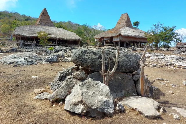
The tombs appear first: grey slabs on short legs scattered between houses and trees, some old and lichen-streaked, some bright with new cement, and beside several of them a tall carved stone standing upright like a sentinel. Then the sound of weaving from under the houses, and lengths of patterned cloth hung out on lines. A few minutes from Waingapu, Kawangu shows two sides of East Sumba at once: its stone memory and its cloth economy.
What it is and why go
Kawangu is a kelurahan in Pandawai district, East Sumba Regency, the same district as Walakiri beach. A study published in August 2016 in Humanis, a humanities journal of Udayana University in Bali, by Ni Nyoman Ayu Vidya Trisna Prilyandani, I Wayan Ardika and Coleta Palupi Titasari, recorded 39 reti (stone tombs) in Kampung Kawangu: 2 large ones, grouped by the ornament of their penji (decorated menhirs), 18 medium-sized ones in limestone or cement, and 19 small ones. The authors describe the reti as symbols of great rulers and of power, places of worship and a form of respect for the ancestors, and call Kawangu's megalithic practice a "living megalithic tradition".
Kawangu is also known for weaving. Asian Textile Studies warns that many cheap blankets sold as Mangili-style ikat are synthetically dyed imitations made in Kawangu. That is not a reason to avoid it, but a reason to ask questions and to understand what you are buying. Our guide to Sumba ikat and where to buy it explains the difference.
Sumba this week, every Sunday
The week's news, one place worth the trip and practical travel notes. Free, and you get our 7-day Sumba guide (PDF) on signing up.
One email a week. No spam. Unsubscribe in one click. Sumba this weekHow to get there
- From Waingapu town: east of the town in Pandawai district; on OpenStreetMap the kelurahan centre is roughly 12 km in a straight line from central Waingapu. Allow about 20-30 minutes by car or ojek.
- From Waingapu airport (WGP): a short drive; easy to combine with Walakiri beach at sunset.
- From Tambolaka (TMC): about 4-5 hours to Waingapu first.
The map point on this page is the kelurahan centre from OpenStreetMap; ask your driver for the tomb areas.
When to go and best time of day
All year. Morning is best for weaving and for soft light on the stones; combine with Walakiri for the late afternoon. The dry season (roughly May-November in the east) brings clear skies and dusty roads.
Tips and etiquette
- Tombs are family graves: ask permission before walking among them, do not sit or climb on them and do not touch the carved stones.
- Donation: if you are shown around, sign any guest book and leave a donation (around IDR 10,000-40,000 per person is common in Sumba, 2025-2026).
- Buying ikat: ask whether a cloth is natural or synthetic dye; both are honest products if labelled honestly. Prices for natural dyes are much higher.
- Photos: ask before photographing weavers or people at home.
- Dress modestly and carry cash.
Plan your visit
A simple half day: leave Waingapu in the early afternoon, spend an hour among the tombs and weavers at Kawangu, then continue east to Walakiri beach for low tide and sunset (check the tide table first), and be back in town for dinner. If you are serious about ikat, visit Kawangu after you have seen natural-dye weaving at Prailiu or in the south-east, so you can compare colours, feel and prices side by side. A cheaper synthetic cloth is not a fake if it is sold for what it is; the problem is only a synthetic cloth sold as natural.
Nearby
- Walakiri beach, the "dancing mangroves" at sunset, also in Pandawai.
- Danau Laipori, a small lake ringed by trees further east in Pandawai.
- Prailiu, the royal village of Waingapu.
- Lambanapu, with its ancient burial site and museum.
Frequently asked questions
How many stone tombs are there in Kawangu?
A 2016 study in the journal Humanis recorded 39 reti: 2 large, 18 medium and 19 small.
Is Kawangu ikat naturally dyed?
Some may be, but Asian Textile Studies notes that many low-cost Mangili-style blankets are synthetically dyed imitations made in Kawangu. Ask the seller, and expect natural dyes to cost much more.
How far is Kawangu from Waingapu?
It is east of town in Pandawai district, roughly 20-30 minutes by car.
Places in this guide
- Kawangu (kelurahan centre) · Pandawai, East Sumba · Open in maps
Distances by road
Kawangu is in Pandawai, East Sumba, on the island of Sumba, Indonesia: 188 km by road from Tambolaka Airport (TMC) (about 4 h 30 min to 5 h 30 min) and 12.6 km from Waingapu Airport (WGP) (about 20 min).
- Regency
- East Sumba (Sumba Timur)
- From Tambolaka Airport (TMC)
- 188 km by road, about 4 h 30 min to 5 h 30 min driving
- From Waingapu Airport (WGP)
- 12.6 km by road, about 20 min driving
- Nearest town
- Waingapu: 18.1 km by road, about 25 min to 30 min
- Coordinates
- -9.7138, 120.3631 · Open in Google Maps ·
- Sunrise and sunset
- Sunrise from 05:27 (November) to 06:16 (July); sunset from 17:45 (May) to 18:26 (January), local time (WITA). Calculated for these coordinates on the 15th of each month.
Combine it in one day. The closest places by road from here, with the driving time between them:
- Bukit Persaudaraan13.2 km · 20 min to 25 min
- Bukit Tanau13.5 km · 20 min to 25 min
- Prailiu village16.7 km · 25 min to 30 min
Road distances were calculated on 18 November 2026 with the OSRM routing engine on OpenStreetMap roads. Driving times are our estimate at an average of 34 to 42 km/h without long stops, the pace at which the 170 km between Tambolaka and Waingapu take 4 to 5 hours. The mapped road ends about 1.9 km from this point: the last stretch is a track or a walk. All distances between towns and places →
Nearby places
- Bukit Tanau8 km straight-line (map point approximate)
- Bukit Persaudaraan9 km straight-line
- Lambanapu10 km straight-line (map point approximate)
- Prailiu village11 km straight-line
Straight-line distances between map points; roads are longer. Getting around Sumba: car with driver, scooter, buses and real driving times
- Kubur batu (reti) di Kampung Kawangu, Kecamatan Pandawai, Kabupaten Sumba Timur, Humanis vol. 16 no. 2, Aug 2016
- Inggi: Mangili men's blankets, Asian Textile Studies (note on Kawangu imitations), accessed Nov 2026
- Kelurahan Kawangu, OpenStreetMap / Nominatim (area coordinates)
Spotted an error? Write to info@ecobeachcity.com.
Sumba this week, every Sunday
The week's news, one place worth the trip and practical travel notes. Free, and you get our 7-day Sumba guide (PDF) on signing up.
One email a week. No spam. Unsubscribe in one click. Sumba this week