Place · Travel
Bukit Tanau, Sumba: savanna sunrise 15 km from Waingapu
Folded green and gold hills above rice fields and a river, close to Waingapu airport: the sunrise hill of East Sumba and how to find it without signs.

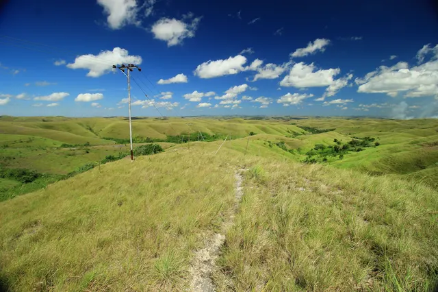
Bukit Tanau (also written Tenau, and known locally as Ruaka Bandil) is a savanna hill in Kambera district, East Sumba, about 15 km from Waingapu. From the top you see rolling grass, rice fields, a river and the sea, and planes landing at the airport. Entry is free; go at sunrise or sunset, with a driver or local who knows the way, as signs are poor.
- Where
- Kambera district, East Sumba (Tanau / Mauliru area), about 15 km from Waingapu
- From the nearest airport
- Waingapu (WGP): about 15 km, roughly 30 minutes
- Best time
- Sunrise or sunset; green in the rains, golden in the dry season
- Entry
- Free (GNFI); keep it clean
- Good for
- Sunrise photography, savanna views, a short walk
Before dawn the hills are only shapes, darker against a sky turning from grey to green to orange. Then the sun clears the horizon and the light runs across the slopes, picking out every fold of grass, the rice fields below, the shine of the river, a thin line of sea. Somewhere a horse snorts. A first plane of the day comes in low over the plain towards Waingapu.
Tanau is the quieter cousin of Wairinding: the same rolling savanna, fewer visitors, and one of the best sunrises near the town.
What it is and why go
Bukit Tanau is a grassy hill area in Kambera district, East Sumba Regency. Sources differ on the administrative detail: a 2023 Times Indonesia article places it in Tanau village, while a 2024 piece and the Spice Route End travel blog place it in Mauliru, the same area as Waingapu airport. All agree on roughly 15 km from Waingapu town.
Sumba this week, every Sunday
The week's news, one place worth the trip and practical travel notes. Free, and you get our 7-day Sumba guide (PDF) on signing up.
One email a week. No spam. Unsubscribe in one click. Sumba this weekTimes Indonesia describes rolling grassy slopes "like the Teletubbies hills", with views of rice fields, a river and the sea, and planes landing nearby; it is popular for pre-wedding photos, though visitor numbers fell after the COVID-19 pandemic. Good News From Indonesia (2020) says entry is free, calls the sunrise a highlight, and notes that the hill was a location for the 2017 Indonesian film Susah Sinyal. The name is also given as Ruaka Bandil or Ruaka Bandi.
How to get there
- From Waingapu town or airport (WGP): about 15 km. The drive passes rice fields and villages; allow roughly 30 minutes.
- From Tambolaka (TMC): about 4-5 hours by car to Waingapu first; this is an East Sumba stop.
Good News From Indonesia warns that signposting is poor, and recommends going with someone who knows the area or asking locals. There is no public transport: use a rented car or motorbike from Waingapu, or an ojek. We could not verify coordinates for the hilltop; the map point on this page is the centre of Mauliru.
When to go and best time of day
- Sunrise: the reason most people come. Leave Waingapu about 45 minutes before sunrise; check the exact time, which shifts through the year.
- Sunset: also good, with warm side light over the hills.
- Dry season (roughly April-October, per GNFI): brown, dry grass and clear skies.
- Rainy season (roughly late October-March): green hills and moodier skies; paths can be muddy.
Tips and etiquette
- Fees: free, according to GNFI. Keep the site clean; there are no bins.
- Horses and herders: Sumba ponies graze here. Ask before photographing herders or children, and agree any payment for posed photos beforehand.
- Bring: a torch for a pre-dawn walk, water, a light jacket for the early wind and sun protection for later.
- Drones: the hill is close to Waingapu airport; check drone rules and do not fly near the approach path.
- Respect the land: this is grazing land owned by local families. Stay on paths and do not light fires.
Plan your visit
A classic first morning in East Sumba: Bukit Tanau at sunrise, breakfast back in Waingapu, then Lambanapu or Prailiu for culture, and Wairinding or Walakiri for the late afternoon. If you only have time for one savanna hill, Wairinding is more famous and easier to find, while Tanau is quieter and closer to the airport. On a departure day with a late-morning or afternoon flight, Tanau at sunrise is often still possible. Ask your driver to confirm the route the evening before, because the turn-offs are easy to miss in the dark.
Nearby
- Bukit Persaudaraan, Waingapu's easy sunset hill near the airport.
- Wairinding Hill, the most famous savanna view in East Sumba.
- Lambanapu, with its archaeological site, museum and weavers.
- Waingapu, the base for exploring East Sumba.
Frequently asked questions
Is Bukit Tanau the same as Bukit Tenau?
Yes. Indonesian sources use both spellings, and locals also call it Ruaka Bandil.
How far is Bukit Tanau from Waingapu?
About 15 km, roughly 30 minutes by car or motorbike. Signs are poor, so go with someone who knows the way.
Is there an entrance fee at Bukit Tanau?
No. Good News From Indonesia reports free entry; visitors are asked to keep the hill clean.
Places in this guide
- Mauliru, Kambera (area centre; Bukit Tanau hilltop coordinates not verified) · Kambera, East Sumba · Open in maps
Distances by road
Bukit Tanau is in Kambera, East Sumba, on the island of Sumba, Indonesia: 178 km by road from Tambolaka Airport (TMC) (about 4 h 15 min to 5 h 15 min) and 3.7 km from Waingapu Airport (WGP) (about under 10 min).
- Regency
- East Sumba (Sumba Timur)
- From Tambolaka Airport (TMC)
- 178 km by road, about 4 h 15 min to 5 h 15 min driving
- From Waingapu Airport (WGP)
- 3.7 km by road, about under 10 min driving
- Nearest town
- Waingapu: 7.7 km by road, about 10 min to 15 min
- Coordinates
- -9.6874, 120.2976 · Open in Google Maps ·
- Sunrise and sunset
- Sunrise from 05:27 (November) to 06:16 (July); sunset from 17:45 (May) to 18:26 (January), local time (WITA). Calculated for these coordinates on the 15th of each month.
Combine it in one day. The closest places by road from here, with the driving time between them:
- Bukit Persaudaraan2 km · under 10 min
- Lambanapu4.8 km · 5 min to 10 min
- Prailiu village6.3 km · 10 min
Road distances were calculated on 18 November 2026 with the OSRM routing engine on OpenStreetMap roads. Driving times are our estimate at an average of 34 to 42 km/h without long stops, the pace at which the 170 km between Tambolaka and Waingapu take 4 to 5 hours. All distances between towns and places →
Nearby places
- Bukit Persaudaraan1 km straight-line
- Lambanapu3 km straight-line (map point approximate)
- Prailiu village4 km straight-line
- Waingapu6 km straight-line
Straight-line distances between map points; roads are longer. Getting around Sumba: car with driver, scooter, buses and real driving times
- Pesona Bukit Tenau yang memukau di timur Sumba, Good News From Indonesia, 23 Aug 2020
- Tiga bukit terindah di Sumba Timur, satunya pernah dijadikan film, Times Indonesia, 2023
- 3 tempat pilihan wisata bukit Sumba Timur yang bisa dinikmati, Times Indonesia, 3 Jun 2024
- Sumba: around Waingapu and Melolo, The Spice Route End (travel blog), 2018
- Kelurahan Mauliru, OpenStreetMap / Nominatim (area coordinates)
Spotted an error? Write to info@ecobeachcity.com.
Sumba this week, every Sunday
The week's news, one place worth the trip and practical travel notes. Free, and you get our 7-day Sumba guide (PDF) on signing up.
One email a week. No spam. Unsubscribe in one click. Sumba this week