Travel
East Sumba (Sumba Timur): what to know before you go
Two thirds of the island, a few hundred thousand people and a lot of sky: how East Sumba works, where to go and what to sort out before you leave Waingapu.
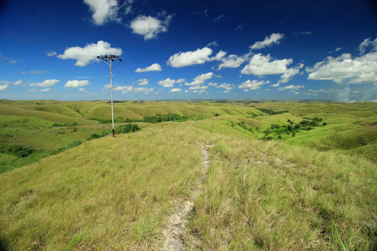
East Sumba (Kabupaten Sumba Timur) is the largest of Sumba's four regencies, about 7,000 km² with roughly 263,000 people (BPS mid-2025 estimate), and its capital is Waingapu, which has an airport (WGP) with non-stop flights from Bali. It is the dry, open half of the island: savanna hills such as Wairinding, north-coast beaches, royal weaving villages around Melolo and the forests of Laiwangi Wanggameti. Go in the dry season, roughly May to November, and take cash, fuel and offline maps from Waingapu.
- Capital
- Waingapu (north coast)
- Size and population
- About 7,000 km²; 262,975 people (BPS mid-2025 estimate)
- Airport
- Umbu Mehang Kunda (WGP), Waingapu; non-stop from Bali 4x a week
- Highlights
- Wairinding, Walakiri, Puru Kambera, Tanggedu, Pau and Rende, Tarimbang
- Best time
- Dry season, roughly May-November
Drive out of Waingapu in August and the colour drains from the land until only gold and blue are left: grass the shade of straw on hills that roll to the horizon, a sky so clear you can see the mountains of Flores across the strait, and horses standing in the only shade for kilometres. Then the road drops into a river valley and everything turns green again, with rice, coconut palms and the tall roofs of a clan village. East Sumba is a place of long distances, few people and very big views.
The short version: East Sumba is the largest and driest of Sumba's four regencies, governed from Waingapu. It covers nearly two thirds of the island but holds less than a third of its people. You come here for savanna, empty beaches, ikat weaving and royal villages, not for nightlife or crowds.
East Sumba at a glance
East Sumba Regency (Kabupaten Sumba Timur) covers about 7,000.5 km², roughly 64% of the island's land area, and had an estimated 262,975 inhabitants in mid-2025, according to BPS figures published on Wikipedia. That is fewer than 40 people per km², the lowest density on Sumba. The regency is split into 22 districts (kecamatan) and 156 villages.
Low Tide, every Sunday
One short letter a week about living well, from an island with more horses than traffic lights. Free.
We only use your email to send the letter. Unsubscribe in one click.The capital, Waingapu, sits on the north coast at the mouth of the Kambaniru River. Together with the neighbouring Kambera district it has a little over 73,000 people, which makes it the largest town on the island. Other centres are Melolo, a trading town in the south-east, and Lewa, roughly halfway along the road to the west.
How to get there
- By air: Umbu Mehang Kunda airport (WGP) is on the edge of Waingapu. TransNusa has flown Bali to Waingapu non-stop four times a week (Tuesday, Wednesday, Friday, Saturday) since 15 July 2026; other routes connect via Kupang.
- From Tambolaka (TMC) in the west: about 170 km and 4-5 hours by car via Waikabubak, Waibakul and Lewa. Buses and shared "travel" cars cover the route in roughly 4-6 hours.
- By sea: Waingapu is the island's main cargo and fuel port, with passenger ships calling on irregular schedules.
A practical plan is to fly into one airport and out of the other, so you cross the island only once. See how to get to Sumba from Bali for flights and ferries.
The landscape
East Sumba is the island's rain shadow. Waingapu receives only about 900 mm of rain a year, and August is almost completely dry. The north-east, from Waingapu up to the northern cape of Tanjung Sasar, is the driest and most thinly populated corner of Sumba: brown and dusty after months without rain, then a soft lime green from about March, after the monsoon. Inland, savanna hills alternate with deep green valleys and limestone ridges.
The south is different again. Rivers run down from the mountains to the Indian Ocean, and the forests of Laiwangi Wanggameti National Park climb to Mount Wanggameti (1,225 m), the highest point on the island. Roads along the south coast are poor and, in places, impassable in the rainy season.
Main places to visit
Around Waingapu
- Prailiu: the royal village between the airport and the town centre, with megalithic tombs and women weaving.
- Bukit Persaudaraan: a flat-topped hill opposite the airport, with views over the rice fields of the Kambaniru plain.
- Wairinding Hill: the classic savanna viewpoint, about 20-25 km west (30-45 minutes).
- Walakiri Beach: dwarf mangroves at sunset, about 20-24 km east (30-35 minutes).
The north coast
- Londa Lima: a calm white-sand beach 9-15 km north-west of town.
- Puru Kambera: savanna, free-roaming horses and shallow water, about 24-26 km from Waingapu.
- Tanggedu Waterfall: water carving through rock in a green canyon, roughly 2 hours away plus a walk. Go on a weekday.
The south-east and south
- Pau and Rende: royal villages near Melolo, 60-70 km from Waingapu, known for huge carved stone tombs and some of Sumba's finest weaving.
- Waimarang Waterfall: a turquoise pool inland from Melolo, reached by a 20-45 minute walk down.
- Tarimbang: a white-sand bay and surf break on the south coast, about 87 km and 3 hours from Waingapu.
Culture: language, weaving and Marapu
The language of the east is Kambera, spoken by about 240,000 people. It takes its name from a traditional domain near Waingapu and became the common language of the east because 19th-century trade was concentrated in the port. Almost everyone also speaks Indonesian; English is rare outside tourism. A few words of Indonesian go a long way: see our Sumba phrasebook.
East Sumba's royal villages are famous for their weaving. In Prailiu, Rende and Pau you can watch weavers at work, and in Melolo a weavers' cooperative sells cloth from the delta villages. Tombs in Rende and Pau are some of the biggest on the island. The ancestral religion, Marapu, remains strong here, and northern Sumbanese tradition places the arrival of the first ancestors at Wunga, near the northern tip.
The Pasola, Sumba's ritual mounted spear battle, is a West and Southwest Sumba tradition and is not held in the east. Read Marapu, ikat and traditional villages before visiting a village: sign the guest book, leave a small donation, dress modestly, ask before photos and never touch tombs or ritual objects.
Practicalities
- Cash: withdraw in Waingapu. The most reliable ATMs for foreign cards are at BNI and Mandiri branches; outside town, machines are rare or absent. Carry small notes for donations and parking.
- Health: the regency hospital, RSUD Umbu Rara Meha, is in Waingapu, with community health centres (puskesmas) in the districts. Serious cases are usually flown to Bali; read our safety and health guide.
- Fuel: petrol stations are in and around Waingapu and a few larger towns. Fill up before day trips. Deliveries to Waingapu stations were cut in mid-October 2026 and queues formed; see getting around Sumba.
- Signal: Telkomsel has the best coverage, but expect none in valleys, the mountains and much of the south. Download offline maps.
- Sundays: many shops close and families go to church.
- Water: keep away from river mouths and mangroves when swimming; crocodiles live in several rivers, including near Melolo and Kambaniru.
When to go
The dry season, roughly May to November in the east, is easiest: clear skies, golden hills and passable side roads. From about December to March the rains turn everything green but some roads, especially in the south, become muddy or blocked. Mornings and late afternoons are best for savanna viewpoints; midday is hot and shadeless all year. East Sumba counted 41,524 visitors in 2025, about one in eight from abroad, so outside Indonesian holidays you will often have viewpoints to yourself. For the island-wide picture see beaches, lagoons and waterfalls and where to stay in Sumba.
Frequently asked questions
What is the capital of East Sumba?
Waingapu, on the north coast. It is the largest town on Sumba, with an airport (WGP) and the island's main port.
How do I get to East Sumba from Bali?
Fly Bali to Waingapu non-stop with TransNusa (four times a week since July 2026), or fly to Tambolaka in the west and drive about 4-5 hours east.
Is East Sumba worth visiting?
Yes, if you like open landscapes, quiet beaches and traditional weaving. It has the island's classic savanna views and royal villages, with far fewer visitors than the west.
When is the best time to visit East Sumba?
The dry season, roughly May to November, for golden hills and easy roads; the rainy months (about December-March) are greener but some southern roads become difficult.
Are there ATMs in East Sumba?
Yes, in Waingapu (BNI and Mandiri are the most reliable for foreign cards). Outside town they are rare, so withdraw enough cash before day trips.
Places in this guide
- Waingapu · East Sumba · Open in maps
- East Sumba Regency, Wikipedia (area, districts, BPS mid-2025 population)
- Kambera language, Wikipedia
- Waingapu, Wikipedia (climate, port)
- The Northeast of Sumba, Sumba Information (Matthias Jungk), accessed Nov 2026
- Waingapu and Surroundings, Sumba Information, accessed Nov 2026
- The Southeast of Sumba, Sumba Information, accessed Nov 2026
- Tips and Tricks (banks, phone, Sundays), Sumba Information, accessed Nov 2026
Spotted an error? Write to info@ecobeachcity.com.
Low Tide, every Sunday
One short letter a week about living well, from an island with more horses than traffic lights. Free.
We only use your email to send the letter. Unsubscribe in one click.