Travel
Walakiri Beach, Sumba: the dancing mangroves at sunset
Small, twisted mangrove trees standing in shallow water, black against an orange sky: how to time the tide and the light at East Sumba's best-known sunset beach.
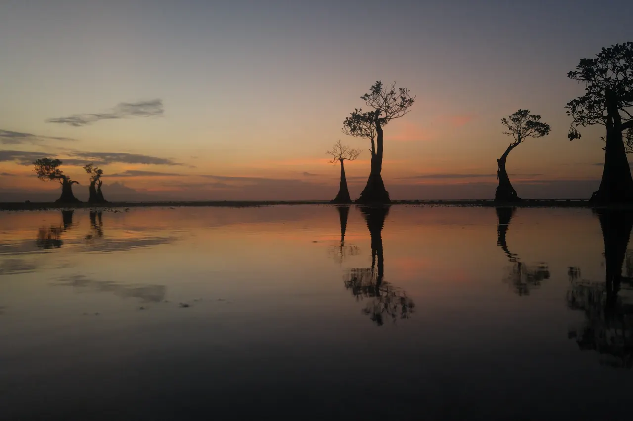
Walakiri Beach is on the north coast of East Sumba, about 20-24 km east of Waingapu (around 30-35 minutes by car), in Watumbaka village, Pandawai district. It is famous for its dwarf mangroves, which look best as silhouettes at low tide around sunset; entry has been free in recent reports, and it is a scenic stop rather than a swimming beach.
- Where
- Watumbaka village, Pandawai district, north coast of East Sumba
- From the nearest airport
- Waingapu (WGP): about 20-24 km, 30-40 minutes by car
- Best time
- Low tide around sunset; dry season (roughly May-October) for clear skies
- Entry
- No ticket in recent reports; small parking contribution possible
- Good for
- Sunset photography, walking the tidal flats, grilled fish
Late afternoon at Walakiri, and the sea has pulled back so far that you can walk out across wet sand and shallow pools. Out on the flats stand the mangroves: small, knotted trees no taller than a person, their trunks bent and their branches thrown out sideways, as if they had stopped mid-dance. As the sun drops toward Sumba Strait the water turns copper, the trees go black, and the only sounds are small waves, children shouting along the shore and the smoke and crackle of fish grilling at a stall behind the beach.
Walakiri is East Sumba's most photographed sunset, and one of the easiest trips from Waingapu. Here is how to time it well.
What it is and why go
Pantai Walakiri is a long, shallow beach of pale sand in Watumbaka village, Pandawai district, facing north onto the strait between Sumba and Flores. What makes it special is the line of short, bonsai-like mangroves (bakau) that grow in the shallows near the shore. Locals and travel writers call them the "dancing mangroves". At high tide they stand in waist-deep water; at low tide the sea can be ankle-deep or dry, and you can walk among them.
Low Tide, every Sunday
One short letter a week about living well, from an island with more horses than traffic lights. Free.
We only use your email to send the letter. Unsubscribe in one click.It is a place to watch, walk and photograph, not to snorkel or swim seriously. The atmosphere is local and relaxed: no beach clubs, no loud music, a few simple stalls selling grilled fish and seafood, and families from Waingapu on weekends and holidays.
How to get there
Walakiri is on the Waingapu-Melolo road east of town. Sources give roughly 20-24 km and about 30-35 minutes by car. There is no direct public transport, so go with a car and driver or by scooter.
- From Waingapu airport (WGP): roughly 30-40 minutes; it works well on your arrival day if you land in the afternoon.
- From Tambolaka (TMC): about 170 km and 4-5 hours to Waingapu, then another half hour. Realistically this is an East Sumba stop, not a day trip from the west.
When to go and best time of day
Timing is everything at Walakiri. The classic image needs low tide close to sunset. At high tide the beach can look plain and the mangroves are half underwater.
- Check a tide table for Waingapu before you go and pick an evening when low water falls in the last hour or two of daylight.
- Arrive around 16:30 to find your angle before the light goes; plan 45 minutes to 1.5 hours, longer for photography.
- The dry season (roughly May-October) usually gives clearer skies and stronger sunsets. In the rainy months the surroundings are greener, but cloud can hide the sun.
- Weekdays are calmer. On holidays such as Lebaran, local media have reported hundreds of visitors a day.
Tips and etiquette
- Fees: recent local reports say there is no entrance ticket. A small parking contribution may be asked; carry small notes for parking and snacks.
- Feet: wear sandals or reef shoes. The flats are uneven and there are sea urchins in the shallows.
- Protect the mangroves: do not climb, hang on or break the trees. They are slow-growing and they are why everyone comes.
- Mosquitoes: bring repellent for dusk.
- People: locals gather shellfish and sea urchins on the flats at low tide. Ask before photographing them and give them space.
- Rubbish: take it back to Waingapu; there are few bins.
- Night drive: the road back is unlit in places and animals wander onto it. Drive slowly.
Nearby
- Waingapu town, 30 minutes west, for food and a bed.
- Prailiu, the royal village between the airport and the town centre.
- Pau and Rende, weaving and royal villages further south along the same road towards Melolo.
- Wairinding Hill, the other classic sunset, west of town.
Frequently asked questions
How far is Walakiri Beach from Waingapu?
Roughly 20-24 km east on the road to Melolo, about 30-35 minutes by car.
What is the best time to see the dancing mangroves?
At low tide close to sunset. Check a Waingapu tide table and arrive around 16:30.
Can you swim at Walakiri Beach?
The water is very shallow at low tide and there are sea urchins, so it is better for wading and photos than for swimming.
Is there an entrance fee at Walakiri?
Recent local reports say there is no ticket. You may be asked for a small parking contribution.
Places in this guide
- Walakiri Beach · East Sumba · Open in maps
- Pantai Walakiri Sumba, pesona mangrove menari di kala senja, Koran Jakarta, 29 May 2026
- Guide to Walakiri Beach, East Sumba, Backindo, Jan 2026 (updated Jul 2026)
- Libur Lebaran di Sumba Timur, warga ramaikan sejumlah obyek wisata, Times Indonesia, Apr 2024
- Unexpected attractions around Waingapu, East Sumba, Live the World
- Pantai Walakiri, OpenStreetMap / Nominatim
Spotted an error? Write to info@ecobeachcity.com.
Low Tide, every Sunday
One short letter a week about living well, from an island with more horses than traffic lights. Free.
We only use your email to send the letter. Unsubscribe in one click.