Place · Travel
Gallubakul, Sumba: the 70-tonne tomb of Umbu Sawola
A single carved stone the size of a small room, dragged 3 km by thousands of people: the story of one of Sumba's heaviest tombs and how to visit it.
Gallubakul is a village in Anakalang, Central Sumba, a few kilometres south of Pasunga, known for the tomb of Umbu Sawola, a single carved stone of about 70 tonnes. Sumba Information says it was the largest on the island until a 79-tonne tomb was raised for Umbu Jadar in 2022. The raja's family lives beside it and asks visitors to sign in and give a donation, reported at IDR 20,000-50,000.
- Where
- Anakalang, Katikutana district, Central Sumba; a few km south of Pasunga
- From the nearest airport
- Tambolaka (TMC): roughly 1.5-2 hours by car
- Best time
- All year; early morning or late afternoon
- Entry
- Sign-in and donation, reported at IDR 20,000-50,000
- Good for
- One of Sumba's heaviest megalithic tombs, local storytelling
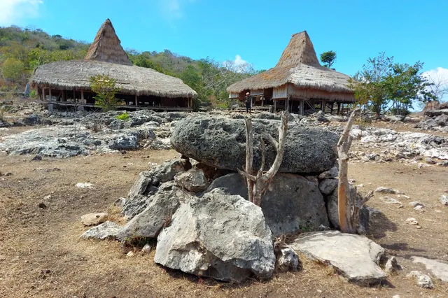
From a distance it looks like a low grey building. Up close it is one piece of rock: a vast flat slab, almost a metre thick, resting on stone supports, its edges cut clean. At one end an upright stone shows a king and queen with buffalo and cockerel figures. Grass grows to the foot of it, a family's laundry dries nearby, and the only sound is the wind across the rice fields of the Anakalang plain.
The tomb of Umbu Sawola at Gallubakul is one of the great monuments of Sumba's living megalithic tradition. This page explains what it is and how to see it respectfully.
What it is and why go
Gallubakul (also written Gallu Bakul or Galubakul) is a village of Anakalang, in Katikutana district of Central Sumba. Its fame is a single tomb. Lonely Planet calls it Sumba's heaviest, at about 70 tonnes, a single carved stone roughly 6 m long, 3.5 m wide and nearly 1 m thick. Wikipedia gives slightly different measurements (5 by 4 m, 1 m thick) for the same 70-tonne block. Local tradition, as told to Lonely Planet, says 6,000 workers spent three years cutting it from a hillside and dragging it 3 km to the village; Wikipedia reports that it was carved from one rock over six years. The figures vary with the teller, which is part of how such stories live.
Sumba this week, every Sunday
The week's news, one place worth the trip and practical travel notes. Free, and you get our 7-day Sumba guide (PDF) on signing up.
One email a week. No spam. Unsubscribe in one click. Sumba this weekThe Sumba Information guide adds a recent chapter: in 2022 the tomb of Umbu Jadar, weighing 79 tonnes, surpassed it, so Umbu Sawola's is now described as the second largest on the island. Megalithic tombs are still being made in Sumba, and the dragging of a great stone remains an event that can involve hundreds or thousands of people. Our guide Marapu, ikat and traditional villages explains why.
How to get there
Wikipedia places Gallubakul about 3.5 km south of Pasunga; Lonely Planet puts it about 2.5 km from Kabunduk (Kabonduk), the village just south of Pasunga. The tomb stands by the road, so a car can stop right next to it.
- From Waibakul / Pasunga: a few kilometres south, around 10 minutes.
- From Waikabubak: roughly 25 km, around 40 minutes.
- From Tambolaka (TMC): roughly 1.5-2 hours by car.
- From Waingapu (WGP): roughly 3 hours or a little more.
When to go and best time of day
Any time of year works; the road is paved to the village. Early morning or late afternoon gives side light on the carved upright stone and is cooler for standing around. The dry season, roughly May to September, is best if you plan to continue to Matayangu waterfall, reached by road south-west from Gallubakul, where the jungle path is steep and slippery after rain.
Tips and etiquette
- Donation: according to Lonely Planet, the raja's son lives beside the tomb, tells its story and asks visitors to sign in and donate IDR 20,000-50,000. Amounts may have changed; carry small notes.
- Listen: the family's account of the tomb is the real attraction. A local driver can translate.
- Respect the grave: do not climb on it, sit on it or lean on the carvings, and keep drones away unless the family agrees.
- Photos: ask before photographing people or houses. Dress modestly.
- Ceremonies: if a funeral or stone-pulling is under way, ask before approaching; it may not be a moment for visitors.
Nearby
- Pasunga, a few kilometres north, with its carved tomb of 1926.
- Waibakul, the Central Sumba capital, for food and fuel.
- Matayangu waterfall, in Manupeu Tanah Daru National Park.
- Manupeu Tanah Daru National Park, the forest that covers much of the south of the regency.
Frequently asked questions
How heavy is the Umbu Sawola tomb?
About 70 tonnes, cut from a single stone. Sumba Information says a 79-tonne tomb raised for Umbu Jadar in 2022 is now larger.
Where is Gallubakul?
In Anakalang, Central Sumba, a few kilometres south of Pasunga and the Waibakul junction (Wikipedia gives about 3.5 km).
Is there an entrance fee at Gallubakul?
No ticket office. The raja's family asks visitors to sign in and donate; Lonely Planet reports IDR 20,000-50,000.
Places in this guide
- Gallubakul · Anakalang, Central Sumba · Open in maps
Distances by road
Gallubakul is in Anakalang, Central Sumba, on the island of Sumba, Indonesia: 63 km by road from Tambolaka Airport (TMC) (about 1 h 30 min to 1 h 50 min) and 121 km from Waingapu Airport (WGP) (about 2 h 50 min to 3 h 35 min).
- Regency
- Central Sumba (Sumba Tengah)
- From Tambolaka Airport (TMC)
- 63 km by road, about 1 h 30 min to 1 h 50 min driving
- From Waingapu Airport (WGP)
- 121 km by road, about 2 h 50 min to 3 h 35 min driving
- Nearest town
- Waibakul: 9.8 km by road, about 15 min
- Coordinates
- -9.6220, 119.5650 · Open in Google Maps ·
- Sunrise and sunset
- Sunrise from 05:30 (November) to 06:19 (July); sunset from 17:48 (May) to 18:29 (January), local time (WITA). Calculated for these coordinates on the 15th of each month.
Combine it in one day. The closest places by road from here, with the driving time between them:
- Pasunga4.1 km · under 10 min
- Waibakul7.1 km · 10 min to 15 min
- Lapopu waterfall10.9 km · 15 min to 20 min
Road distances were calculated on 18 November 2026 with the OSRM routing engine on OpenStreetMap roads. Driving times are our estimate at an average of 34 to 42 km/h without long stops, the pace at which the 170 km between Tambolaka and Waingapu take 4 to 5 hours. All distances between towns and places →
Nearby places
- Waibakul4 km straight-line
- Pasunga4 km straight-line
- Matayangu waterfall9 km straight-line
- Lapopu waterfall10 km straight-line
Straight-line distances between map points; roads are longer. Getting around Sumba: car with driver, scooter, buses and real driving times
- Gallu Bakul, Lonely Planet, accessed Nov 2026
- Anakalang, Wikipedia (Umbu Sawola tomb, distances), accessed Nov 2026
- Waibakul, Anakalang and Surroundings, Sumba Information (Umbu Jadar tomb, 2022), accessed Nov 2026
- Gallubakul, OpenStreetMap / Nominatim (coordinates)
Spotted an error? Write to info@ecobeachcity.com.
Sumba this week, every Sunday
The week's news, one place worth the trip and practical travel notes. Free, and you get our 7-day Sumba guide (PDF) on signing up.
One email a week. No spam. Unsubscribe in one click. Sumba this week