Place · Travel
Pasunga, Sumba: the carved royal tomb beside the main road
A chief and his wife carved in stone in 1926, hands on hips, watching the traffic on the Anakalang plain: how to visit Pasunga with respect.
Kampung Pasunga is a traditional village in Anakalang, Central Sumba, right beside the main road at the Waibakul junction, about 22 km east of Waikabubak. Its best-known tomb has an upright stone slab carved with a chief and his wife, made in 1926 over six months for a funeral at which 150 buffaloes were sacrificed. There is no fixed ticket: sign the guest book and leave a small donation.
- Where
- Anakalang, Katikutana district, Central Sumba; beside the main road at the Waibakul junction
- From the nearest airport
- Tambolaka (TMC): about 60 km, roughly 1.5 hours
- Best time
- All year; morning or late afternoon light for the carvings
- Entry
- No fixed fee; guest book and donation (around IDR 10,000-40,000 is common)
- Good for
- Seeing a great carved megalithic tomb up close
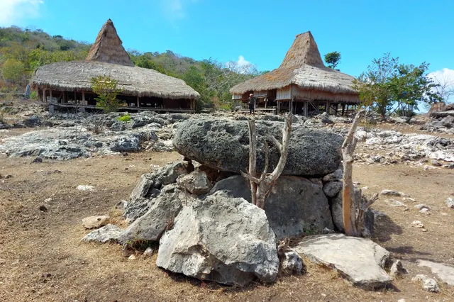
Trucks and buses rumble past a few metres away, but inside the low stone wall the noise seems to fade. Massive grey slabs rest on squat legs, roofs of the clan houses rise behind them, chickens pick at the dust between the graves. And there, upright at the end of one tomb, the slab everyone stops for: a man and a woman carved in relief, standing side by side with their hands on their hips, stern and calm, as they have stood since 1926.
Pasunga is the easiest place in Sumba to see a great carved tomb up close. Here is what you are looking at, and how to visit well.
What it is and why go
Pasunga is one of the traditional villages (kampung) of Anakalang, the old domain on the central plain of western Sumba, now in Katikutana district of Central Sumba Regency. Anakalang is known for the largest and most richly carved megalithic tombs on the island, and Pasunga holds one of the most impressive. Lonely Planet and Wikipedia both describe its upright slab carved with the figures of a chief and his wife: it dates from 1926, took six months to carve, and was made for a funeral at which 150 buffaloes were sacrificed. Wikipedia adds that the buffalo horns are kept in a house in the village.
Sumba this week, every Sunday
The week's news, one place worth the trip and practical travel notes. Free, and you get our 7-day Sumba guide (PDF) on signing up.
One email a week. No spam. Unsubscribe in one click. Sumba this weekThese are not museum pieces. In Sumbanese tradition, linked to the Marapu belief in the ancestors, a stone tomb is the house of the dead, and dragging and raising such a stone is one of the biggest events in the life of a clan. Funerals with stone dragging still happen around Anakalang today. Read Marapu, ikat and traditional villages for the background.
How to get there
Pasunga is on the main road, just off the junction at Waibakul, so you cannot really miss it. The Sumba Information guide notes that the public buses between Waingapu and Waikabubak stop right outside the village.
- From Waikabubak: about 22 km east, around 30 minutes by car.
- From Tambolaka (TMC): about 60 km, roughly 1.5 hours via Waikabubak.
- From Waingapu (WGP): a little over 100 km west, roughly 3 hours via Lewa.
When to go and best time of day
Pasunga can be visited all year. Morning or late afternoon light brings out the relief carving best; at midday the slab is flat and the stones are hot. The dry season, roughly May to September, makes it easy to combine with other villages of the plain. If you happen to pass during a funeral or ceremony, stay back and ask your driver whether visitors are welcome before going in.
Tips and etiquette
- Donation: there is no published entrance fee. As in most Sumbanese villages, you will usually be asked to sign a guest book and leave a donation; around IDR 10,000-40,000 per person is a common range (2025-2026).
- Ask first: greet whoever is around, ask permission before entering the tomb area and before photographing people. Lonely Planet describes the village elders as friendly and willing to explain the tombs.
- Do not touch or climb: never sit or stand on a tomb, and do not touch carvings, offerings or ritual objects.
- Dress modestly: shoulders and knees covered. A small gift of betel nut (sirih pinang) bought at a market is a traditional courtesy.
- Go with a local: a driver or guide from the area makes conversation possible; little English is spoken.
Nearby
- Waibakul, the small capital of Central Sumba, across the junction.
- Gallubakul, a few kilometres south, with the 70-tonne tomb of Umbu Sawola.
- Kabunduk, about 1 km south of Pasunga, where old and new houses mix; from here, with a local companion, paths climb to hilltop hamlets such as Lai Tarung.
- Tarung in Waikabubak, about 30 minutes west, for a ritual village on a hill.
Frequently asked questions
What is special about the Pasunga tomb?
Its upright stone slab is carved with the figures of a chief and his wife. It dates from 1926, took six months to carve and was made for a funeral at which 150 buffaloes were sacrificed.
Where is Kampung Pasunga?
In Anakalang, Central Sumba, beside the main road at the Waibakul junction, about 22 km east of Waikabubak.
Do I have to pay to visit Pasunga?
There is no published ticket. Sign the guest book and leave a small donation; around IDR 10,000-40,000 per person is common in Sumbanese villages.
Places in this guide
- Kampung Pasunga · Anakalang, Central Sumba · Open in maps
Distances by road
Pasunga is in Anakalang, Central Sumba, on the island of Sumba, Indonesia: 61 km by road from Tambolaka Airport (TMC) (about 1 h 25 min to 1 h 50 min) and 117 km from Waingapu Airport (WGP) (about 2 h 45 min to 3 h 25 min).
- Regency
- Central Sumba (Sumba Tengah)
- From Tambolaka Airport (TMC)
- 61 km by road, about 1 h 25 min to 1 h 50 min driving
- From Waingapu Airport (WGP)
- 117 km by road, about 2 h 45 min to 3 h 25 min driving
- Nearest town
- Waibakul: 6.1 km by road, about 10 min
- Coordinates
- -9.5878, 119.5750 · Open in Google Maps ·
- Sunrise and sunset
- Sunrise from 05:30 (November) to 06:19 (July); sunset from 17:48 (May) to 18:29 (January), local time (WITA). Calculated for these coordinates on the 15th of each month.
Combine it in one day. The closest places by road from here, with the driving time between them:
- Gallubakul4.1 km · under 10 min
- Waibakul6.6 km · 10 min
- Lapopu waterfall14.9 km · 20 min to 25 min
Road distances were calculated on 18 November 2026 with the OSRM routing engine on OpenStreetMap roads. Driving times are our estimate at an average of 34 to 42 km/h without long stops, the pace at which the 170 km between Tambolaka and Waingapu take 4 to 5 hours. All distances between towns and places →
Nearby places
- Gallubakul4 km straight-line
- Waibakul5 km straight-line
- Matayangu waterfall12 km straight-line
- Lapopu waterfall13 km straight-line
Straight-line distances between map points; roads are longer. Getting around Sumba: car with driver, scooter, buses and real driving times
- Kampung Pasunga, Lonely Planet, accessed Nov 2026
- Anakalang, Wikipedia (tombs, carvings, location), accessed Nov 2026
- Waibakul, Anakalang and Surroundings, Sumba Information, accessed Nov 2026
- Traditional villages in Sumba: which ones to visit and what to expect, Backindo, accessed Nov 2026
- Pasunga Cultural Village, OpenStreetMap / Nominatim (coordinates)
Spotted an error? Write to info@ecobeachcity.com.
Sumba this week, every Sunday
The week's news, one place worth the trip and practical travel notes. Free, and you get our 7-day Sumba guide (PDF) on signing up.
One email a week. No spam. Unsubscribe in one click. Sumba this week